Newark – A Railroad Town from the Beginning
by Jack Burgess, Publicity Chair
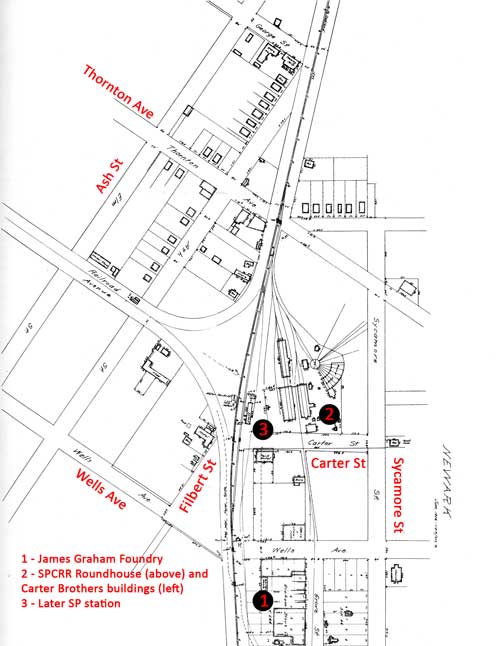 Newark, site of this year’s PCR Convention, has been a railroad town since it was laid out in 1876. Those who have one of Bruce MacGregor’s three books on the narrow-gauge South Pacific Coast Railroad, or have heard of the railroad, will know that Newark was the location of the SPCRR roundhouse and backshops, as well as the location of Carter Brothers, which built narrow-gauge rolling stock for railroads all over the West Coast.
The South Pacific Coast Railroad initially ran from a wharf on the San Francisco Bay, south of current-day Highway 84, to Newark and then turned south to San Jose and eventually Santa Cruz. While there are no remains left of the narrow gauge operations, the standard gauge rails which replaced the 3-foot trackage in 1906 still carry a large number of UP, commuter, and Amtrak trains each day.
To visit the location of the SPCRR shops and Carter Brothers operations, turn left/south from the driveway of the Convention Hotel onto Balentine Drive and then immediately turn right/west at the traffic signal at Stevenson Boulevard. Continue about a half mile and turn right/north at the traffic signal at Cherry Street. Continue 2¼ miles north on Cherry Street and turn left/west at the traffic signal at Central Avenue. Turn right/north on the first street you come to, which is Sycamore Street.
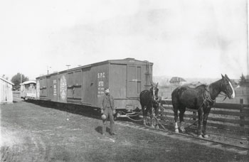 A quarter-mile north on Sycamore Street will be a four-track UP grade crossing. This was originally the single-track, narrow gauge SPCRR horse-drawn branch line from Newark to nearby Centerville, one of the small towns which ultimately became Fremont. The branch continued around the curve adjacent to the apartments on the far side of the grade crossing to the SP Newark station, which was on Carter Street. This branch line originally extended easterly only as far as Centerville, about 3 miles away.
Sometime after the SPCRR was purchased by the SP and standard-gauged in 1906, the branch line was extended through Niles Canyon and beyond. The single curve to the left eventually became part of the current-day wye connecting the branch line to the SP Mulford Line from Oakland to San Jose. The single-story Newark Tower was located within this wye and controlled movements through this wye and another wye a quarter mile to the north, which connected the Mulford Line to the Dumbarton railroad bridge. (Webmaster's note: The Newark Tower CTC board is on display at the South Bay Historical Railroad Society's museum, 1005 Railroad Avenue, Santa Clara, CA, and is open during the convention for a Layout Tour.)
Continue north on Sycamore Street. The apartments on the left are where the James Graham Foundry was located. The foundry supplied metal car castings to Carter Brothers. After Carter Brothers closed around 1906, the Graham Foundry began casting manhole covers and eventually Wedgwood stoves. Across the street is the Rose of Sharon Chapel, originally the Catholic church built by the owners of the SPCRR.
Turn left/west on the first street on the left which is Carter Avenue. The house on Sycamore Street directly across from Carter Avenue was originally the station agent’s house.
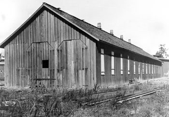
The north end of the Carter Brothers erection shop circa 1913 after the shops were abandoned. – Collection Bruce MacGregor
The open field on Carter Avenue to the right beyond the new housing development was once the location of the Carter Brothers rolling stock building operation. One hundred thirty-five years ago, you would have been looking at the back of the erection shop and paint shop. The SPCRR turntable and roundhouse would have been about in the middle of the large vacant lot, slightly encroaching into the current housing development.
Continuing west on Carter Avenue, the last Newark SP station was on the right just before crossing the tracks. As you cross the railroad tracks, look to the right and you can see the remains of the wye connecting the Mulford Line with the Dumbarton bridge crossing. The remains of this line and the inactive Dumbarton railroad bridge are currently owned by the San Mateo County Transportation Authority.
Continue on Carter Avenue across the tracks (Carter Avenue becomes Filbert Street) and turn right on the first street, which is Wells Avenue. Turn right again on the second street, Ash Street, which then crosses the other end of the wye. The original narrow gauge SPCRR line was on this same alignment for about a mile to the west before turning slightly toward the north to continue to the wharf at Dumbarton Point.
As you reach Thornton Avenue, the building on the left is Watkins Hall, built in 1889 as a saloon, meeting room, and dance hall. Turn right/east onto Thornton Avenue.
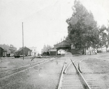
As you cross the railroad tracks, look to the right (or stop on the far side of the tracks next to the plaque behind the sidewalk). If you were standing here 135 years ago, you have been looking at the arcade-style station situated over the mainline and the SPCRR roundhouse and turntable on the left.
The view in the photo (right) looks south from Thornton Avenue toward the SPCRR arcade-style station. The water tank is visible in the trees to the right/west of the station, while the tracks on the right led to Dumbarton Point until 1880; after that year, they stopped at a wood yard near Ash Street for fuel for the locomotives. The Carter Brothers car shops are easily visible to the left of the station (Collection Bruce MacGregor)
The building just across the tracks on the left was originally the State Bank, the first bank in Newark. It is now the La Piñata Mexican Restaurant. Their lunch specials are great and reasonably priced and a window booth will let you watch UP trains on the Mulford Line. Continue east on Thornton Avenue and turn right/south at the first traffic signal which will be Cherry Street. (The Pavillon at the corner of Thornton Avenue and Cherry Street was originally picnic grounds with tennis courts and fountains, all developed by the owners of the SPCRR.) Continue south on Cherry Street, turn left at Stevenson Boulevard, then left at Balentine Drive to return to the Convention Hotel.
Print the above turn-by-turn driving directions.
This page last updated:
